11:00 - 12:30 UTC +10 (Brisbane)
12:00 - 1:30 UTC +11 (Sydney, Melbourne, Hobart)
11:30 - 1:00 UTC +10.5 (Adelaide)
10:30 - 12:00 UTC +9.5 (Darwin)
9:00 - 10:30 UTC + 8 (Perth)
Via Zoom
Join us for this timely webinar exploring fire in the Australian landscape, how earth observation and remote sensing can be used to understand fire severity and extent, and EO and remote sensing's important role in fire management.
Our presenters are:
Dr Marta Yebra, ANU
Remote Sensing Contributions to Bushfire Science and Management
Phil McKenna, UQ
Planet, Drone and dNDVI/dNBR Fire Severity Mapping
Dr Leo Hardtke, Qld Department of Environment and Science & UQ
Operational Fire Extent Mapping with Sentinel-2
Presentations will be followed by a Q&A session moderated by Dr Andrew Edwards from the Darwin Centre for Bushfire Research, Charles Darwin University. Your questions and comments will be welcome through the webinar chat window. See presenter bios.
Join the Webinar from PC, Mac, Linux, iOS or Android: https://uqz.zoom.us/j/564517766
(see connectivity details below)
Registration is not required for this webinar
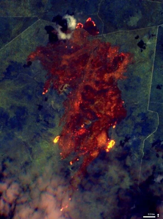
Image: Sentinel-2A image, 2016, near Inglewood, Southern Qld. Displayed with spectral bands 12 (short wave infrared), 11 (short wave infrared), and 8 (near infrared). Supplied by the European Space Agency and processed by the Queensland Government’s Remote Sensing Centre.
Webinar connectivity options
Join from PC, Mac, Linux, iOS or Android: https://uqz.zoom.us/j/564517766
Or iPhone one-tap (Australia Toll): +61280152088,564517766#
Or Telephone:
Dial: +61 2 8015 2088
Meeting ID: 564 517 766
International numbers available: https://zoom.us/u/aAOHAhtzN
Or a H.323/SIP room system:
Dial: SIP:7588@aarnet.edu.au
or H323:564517766@182.255.112.21 (From Cisco)
or H323:182.255.112.21##564517766 (From Huawei, LifeSize, Polycom)
or 162.255.37.11 or 162.255.36.11 (U.S.)
Meeting ID: 564517766
Or Skype for Business (Lync):
SIP:564517766@lync.zoom.us
Our presenters
Andrew Edwards
Dr Andrew Edwards is a researcher at the Darwin Centre for Bushfire Research, Charles Darwin University. Andrew has worked in GIS and Remote Sensing primarily applying these skills to Fire Ecology. Andrew is involved with the North Australia Fire Information web portal, providing burnt area mapping and other fire information to 70% of the Australian continent, including the Tropical Savannas and Rangelands. Andrew is part of the team of scientists and Indigenous land managers responsible for the development of the “Savanna Burning” methodology, earning project areas in North Australia millions of dollars annually through Greenhouse Gas Emissions Abatement. Currently, Andrew is further refining Savanna-wide fire severity mapping to improve the Savanna Burning methodology, whilst working on other projects to assist Indigenous Rangers to monitor and evaluate Bushfire management.
Marta Yebra
Dr Marta Yebra is a Senior Lecturer in Environment and Engineering at the Fenner School of Environment & Society and Research School of Aerospace, Mechanical, and Environmental Engineering ), Mission Specialist of the ANU Institute for Space and Associate editor for Remote Sensing of Environment.
Her research focuses on using remote sensing data to monitor, quantify and forecast natural resources and natural hazards with a focus on mapping bushfire risk and impact at local, regional and global scales.
From 2004-2010 she was employed at the University of Alcala (Spain) where she was involved in two large multidisciplinary projects which assessed and integrated the main fire risk factors and analysed fire risk trends at regional and global scale. During her research, she spent time at the University of California at Davis, the National Institute of Agricultural Technology (Argentina) and Salford University (UK).
From 2010 to 2013 Marta was a postdoctoral fellow at CSIRO Land and Water as developing innovative remote sensing methods to predict carbon-water coupling.
Marta’s research has been recognised through numerous awards, including the Max Day Environmental Science Fellowship from the Australian Academy of Science (2017), the CSIRO Pyne-Scott Career Award (2013) and the Award for Outstanding Achievement in Research Utilisation from the Bushfire and Natural Hazards CRC.
Phil McKenna
Phill McKenna is an ecologist and research scholar at the Centre for Mined Land Rehabilitation, the University of Queensland, assessing the resilience and response of rehabilitated land following controlled and uncontrolled fires. Phill is using a number of sensors to map fire severity and vegetation recovery and is currently assessing multiple burns using remote sensing and ground flora surveys.
Leo Hardtke
Dr Leonardo Hardtke is a Research Officer at the School of Earth and Environmental Sciences, University of Queensland since 2018.
He is a spatial ecologist, graduated from the Universidad Nacional del Comahue, Argentina. His interest in wildfires started early in his career, studying the ecological role of fire and its interactions with the environment and the economic activities in Patagonia, Argentina.
In his current role, Leonardo’s main research priority has been to develop and operationalize a method to map fires from Sentinel-2 imagery Queensland wide close to real-time.